|
|
||||||||||
 |
||||||||||
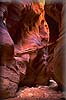
| Buckskin Gulch
[462AV, Leica R8, 28-70 mm Vario Elmarit; 25 sec f/16, Fuji Velvia, 6-9-00]
Buckskin Gulch straddles the Utah-Arizona border in the Paria Canyon-Vermillion Cliffs Wilderness Area. The Wire Pass trailhead is located 8.3 miles south of Highway 89 westward of Page, Arizona at MileMaker 24 on Rock House Valley Road and leads to Buckskin Gulch, 2.8 miles downstream from the Buckskin trailhead. This area is reputed to be the best-known, narrow slot canyon hike in the southwest. This area of two linked narrow desert canyons is a relentless stretch of a tributary of the Paria River which contains walls of Navajo sandstone that tower over you with complex sculpted shapes while confining you at times to spaces as tight as three feet wide. From end to end, this unique hiking experience is an incredible journey of some 16 miles where erosion from numerous floods has long been producing a tapestry of lines on the curving walls that change around each corner, beckoning you deeper and deeper into its depths in order to see what more surrealistic sculpting nature has created just ahead. This Image: Here in the Cockscomb, mute evidence of the tremendous power generated by flash floods in this area is seen: an enormous log is tightly wedged between the narrow rocky walls thirty feet above the riverbed level. When it does flood, there are long stretches of the canyon such as this from which no escape is possible due to smooth, sheer, and sometimes overhanging walls. |
||||||||||
| RETURN TO FRONT PAGE | ||||||||||